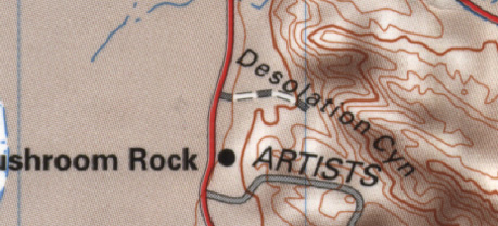
Desolation Canyon is found at the end of a small dirt road off of
the road to the Badwaters, a short ways before Artist's Palette.
Cars can make it on this dirt road with little difficulty. After
parking your car at the end of the road, walk further away from the
main road you turned off of (over all those tricky hills and such),
and keep looking to your right until the peaks start to line up.
Then move away from the canyon, *not* towards it, until things line
up. We hiked up into the canyon for about an hour looking for the
exact location because we didn't appreciate the scale of the film
shots, and should have just backed up a bit instead of hiking so
deep into the canyon. Maybe the 97o heat was getting to
us. After hiking so far up into the canyon decided to head back to
the ranger station and try to talk to Charlie again. We couldn't
find Charlie, but we did talk to another ranger who was kind enough
to show us some slides they had taken during the original 1976
shoot! It was quite cool to stumble onto these never-before-seen
photographs. Cooled off now, we decided to head back and look for
the obvious...this time we found it easily. We noticed none of the
sites are very far from a road. The film crew didn't want to haul a
lot of equipment all over the desert.

Comparison Shot - Spring 1976 vs. Oct. 2000
GPS Coordinates
N 36o 23.622'
W 116o 49.890'
Elevation: 43 ft.
As you can see, almost nothing in
Bantha Canyon has changed. Most everything here is rock so it makes
sense that it wouldn't. Our shots were not taken at the same time of
day as the original shots, which explains why the shadows are all
different. You'll notice in the image above that you can't see as
much of the mountains in the background (on the horizon) as in the
film shot. The film shot was taken from an elevated position. I
searched around for something they might have been standing on, but
the area is very flat. They must have had some kind of lift/platform
that they brought out for this shot, and probably the others as
well.

Comparison shot - Spring 1976 vs. Oct. 2000

Comparison shot - Spring 1976 vs. Oct. 2000
GPS Coordinates
N 36o 23.622'
W 116o 49.848'
Elevation: 52 ft.
This image was scanned from Insider #48. As
you can tell by the circles, this is the same location. We found it
by looking for what we dubbed "nose rock"...a protusion from the
cliff which looks like a nose. It almost makes a whole face, as you
can see some other lines inscribed in the rocks appear to form an
eye (also circled.) The lowest circle shows a slight overhang, which
has since collapsed. You will see this wall by standing right where
the Bantha stood when the Tusken Raider jumped onto him, and turning
180 degrees away from the road. Wala! There is nose rock.

Comparison shot - Spring 1976 vs. Oct. 2000
This is the image Luke
sees when looking through his Macrobinoculars. Strange how our hero
was sitting in Tunisia when he looked through them, yet he sees a
location in Death Valley, CA... We were able to I.D. this location
by noting the overhang seen through the binocs is the same one seen
in the Insider pic. Unfortunately, the pic we took is from a diff.
angle, and we should have been much further to the right. Still, by
looking at all the evidence you can clearly see this is the same
place!

Checking reference images on the laptop

Visiting The Set Goes Online


The latest section to swfans.net is now online, and should be expanding soon!
(c) Copyright, site concept by Jason Freiert, 1999
This site is in no way affiliated with Lucasfilm Ltd. or affiliates of Lucasfilm Ltd.
|